Vintage cartography, the art and science of mapmaking in bygone eras, offers more than geographical information. It is a gateway into the thoughts, beliefs, politics, and aesthetics of the past. From hand-drawn medieval mappae mundi to the meticulously engraved nautical charts of the Age of Discovery, old maps capture humanitys evolving understanding of the world. Today, collectors, historians, and design enthusiasts treasure vintage maps for their artistic value, historical significance, and cultural symbolism. This article delves into the origins, artistry, significance, and modern-day fascination with vintage cartography.
The Origins of Ancient Mapmaking
Cartography dates back thousands of years. Some of the earliest known maps come from Mesopotamia, where clay tablets depicted river systems and city plans. In ancient Greece, philosophers like Anaximander and Ptolemy conceptualized the Earths shape and celestial relationships. Ptolemys Geographia, written in the 2nd century, became a foundational text for mapmakers throughout the Middle Ages and Renaissance. Early Chinese, Indian, and Islamic civilizations also developed sophisticated mapping techniques, each shaped by their respective cosmologies and technological advances.
These early maps were not always geographically accurate by modern standards. Instead, they combined fact and myth, reality and religion. Medieval European maps, for example, often placed Jerusalem at the center and included biblical elements such as Paradise or monstrous races believed to inhabit far-off lands.
The Age of Exploration and the Rise of Accurate Maps
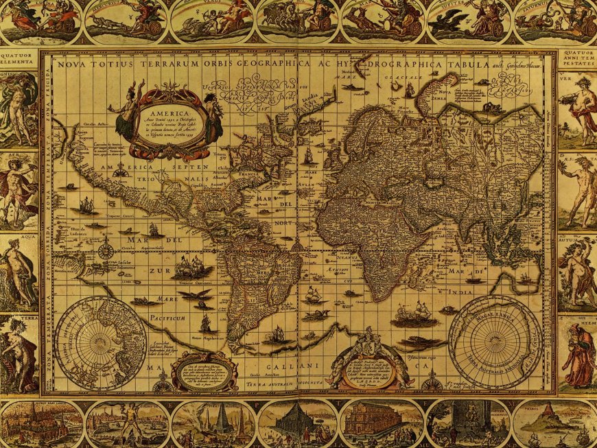
The 15th to 17th centuries marked a turning point in cartography. With the Age of Exploration came a hunger for precise navigational tools. Explorers like Columbus, Magellan, and Vasco da Gama ventured into unknown territories, and their discoveries necessitated better maps. The invention of the printing press enabled the mass production of maps, and advances in mathematics and astronomy led to greater accuracy.
This era saw the emergence of famed cartographers such as Gerardus Mercator, Abraham Ortelius, and Martin Waldseemller. Mercators 1569 world map, introducing the Mercator projection, revolutionized navigation by representing lines of constant compass bearing as straight segments. Ortelius, often credited with creating the first modern atlas, made maps accessible to a broader audience. Waldseemllers map was the first to name the New World America, after explorer Amerigo Vespucci.
These vintage maps not only charted coastlines and continents but also included elaborate illustrations, mythical sea creatures, allegorical figures, and ornate borders that reflected the mapmakers worldview and the spirit of the time.
Aesthetic and Artistic Dimensions of Vintage Maps
Beyond their scientific function, vintage maps are prized for their artistry. Cartographers of the Renaissance and Enlightenment periods were often artists in their own right. Maps were decorated with ships, sea monsters, compass roses, cherubs, and coats of arms. These embellishments served both decorative and symbolic purposes, conveying imperial power, religious beliefs, or fantastical tales of unexplored lands.
Color played a crucial role in the aesthetic appeal of these maps. Hand-colored maps used rich pigments like lapis lazuli, ochre, and vermilion to highlight borders, topography, and illustrations. Some maps were printed in black and white and colored later by hand for wealthy patrons. Each map became a unique piece of art, reflecting not just geography but the culture and aspirations of the mapmakers world.
The Role of Maps in Power and Propaganda
Maps have always been tools of influence. Vintage cartography often served political or ideological agendas. Rulers commissioned maps to legitimize territorial claims or demonstrate the grandeur of their empires. Colonizing nations used maps to define and divide new lands, asserting control over indigenous peoples and natural resources.
In some cases, map distortions were intentional. Cartographers would enlarge certain territories to emphasize their importance or shift borders to reflect political aims. Maps were even used in religious contexts, portraying pilgrimage routes, sacred geography, or biblical events with theological overtones.
The famed T and O maps of the Middle Ages, which placed Jerusalem at the center and divided the world into three parts (Asia, Europe, Africa), reflect not geographic knowledge but Christian cosmology. Such examples show how maps, while appearing objective, were often deeply subjective instruments of power and perception.
Collecting Vintage Maps: A Modern Passion
Today, vintage cartography has become a coveted collectible field. Collectors range from academic institutions and museums to private enthusiasts and interior designers. Original maps from the 16th to 19th centuries, depending on rarity, condition, and provenance, can command high prices at auctions.
Map collectors value authenticity, historical context, and artistic quality. A well-preserved map by a master cartographer like Blaeu, Hondius, or Speed is not only a historical document but also an investment and a statement piece. Some collectors focus on specific themesnautical charts, celestial maps, city plans, or exploration routeswhile others seek maps related to their ancestry or regions of interest.
In addition to originals, high-quality reproductions have become popular in interior dcor. These reproductions bring the charm and nostalgia of antique cartography into modern homes, offices, and public spaces.
Technological Advances and the Study of Historical Maps
Modern technology has enhanced our ability to study vintage cartography. High-resolution digital scanning allows for detailed examination without handling fragile originals. Geographic Information Systems (GIS) can overlay ancient maps onto contemporary ones, helping historians trace changes in landscapes, borders, and settlements.
Projects like the David Rumsey Map Collection and the British Librarys online map archive have made thousands of historical maps accessible to scholars and the public worldwide. These resources not only preserve cultural heritage but also open new avenues of interdisciplinary research across history, geography, art, and sociology.
Cultural and Educational Significance of Vintage Maps
Vintage maps are more than relics; they are storytellers. They narrate humanitys quest to understand, organize, and represent the world. In classrooms and museums, they help students visualize historical events, migration patterns, trade routes, and empire-building. They spark curiosity about geography, exploration, and the evolution of scientific thought.
Moreover, vintage maps invite critical thinking. By comparing old and new maps, learners can explore how perspectives, biases, and technologies shape our view of the world. They remind us that geography is not fixed but a reflection of human understanding at a given time.
Preservation and Ethical Considerations
Preserving vintage maps poses challenges. Paper, ink, and pigment degrade over time, and improper storage can accelerate deterioration. Conservation requires climate-controlled environments, careful handling, and sometimes professional restoration.
Ethical questions also arise regarding the ownership and repatriation of historical maps. Some maps were acquired during colonial periods or through dubious means. Institutions and collectors must consider the cultural significance of these maps to originating communities and ensure that access and interpretation are handled respectfully.
Conclusion: Mapping the Human Spirit
Vintage cartography is far more than an antiquarian niche. It is a vivid testament to human curiosity, ambition, imagination, and ingenuity. Each map captures a snapshot of the world as it was knownor imaginedat a moment in time. Through their lines, labels, and legends, vintage maps trace not only territories but also the evolution of civilization itself.
As we navigate the digital age, the enduring appeal of vintage maps lies in their tangible artistry and intellectual depth. They are reminders that behind every border drawn or ocean charted was a person striving to make sense of the vast unknown. In studying these old maps, we dont just explore the pastwe rediscover the spirit of exploration itself.